
- * Cruises *
- * Group Travel *
- Alaska
- Alicante
- Amsterdam
- Argostoli
- Athens
- Australia/ New Zealand
- Barcelona
- Bari
- Belfast
- Berlin
- Bologna
- Bruges
- Brussels
- Budapest
- Caribbean
- Chianti
- Cinque Terre
- Copenhagen
- Corfu
- Dubai
- Dublin
- Dubrovnik
- Edinburgh
- Egypt
- Ephesus
- Florence
- Genoa
- Helsinki
- Iceland
- India
- Interlaken
- Israel
- Istanbul
- Italy
- Katakolon
- Klaipeda
- Koper
- Kotor
- La Spezia
- Lake Como
- Liverpool
- Livorno
- London
- Lyon
- Madrid
- Malaga
- Marseilles
- Milan
- Monte Carlo
- Mykonos
- Naples
- Nice
- Normandy
- North America
- Palma de Mallorca
- Prague
- Ravenna
- Rhodes
- Rome
- Salzburg
- Santorini
- Sicily
- Siena
- Sorrento
- South America
- Split
- St. Petersburg
- Stockholm
- Tallinn
- Toulon
- Tuscany
- Valencia
- Valletta
- Venice
- Vienna
- Zurich

Accessible Transportation in Paris
Getting around Paris with a disability
Paris accessible transportation provides several options for getting around Paris with a disability. It is best done with a combination of walking/rolling and Paris accessible transportation options including taxis and buses. Only a few of the subway stations are accessible and they are described below. When we visited in 2010, we found that Paris sidewalk accessibility was generally good in the tourist areas of town with curb cuts at intersections and wide sidewalks. In some places they can be uneven; obstructed by bikes, motorcycles, and tables; or have steep curb cuts into the intersection. That being said, the sidewalks are still manageable in a wheelchair, particularly if you are on a major street.
Some of the tourist sights in Paris are near each other, but many of them are spread out which means you will need to take busses or taxis to get between them. Notre Dame and the Sainte-Chapelle church are both on the Ile de la Cité island in the middle of the Seine River. The Musée d’Orsay is just across the river from the Louvre Museum and the Orangerie Museum. The Pompidou Centre and the Jewish Art and History Museum are near each other. The Rodin Museum and Les Invalides are near each other on the left bank and are about one mile (1.4 km) away from the Eiffel Tower. The Arc de Triomphe, Marmottan Monet Museum, Jacquemart Andre Museum, and Sacre Cœur Basilica are spread out to the west and north of the other tourist sights.
Bus Accessibility in Paris
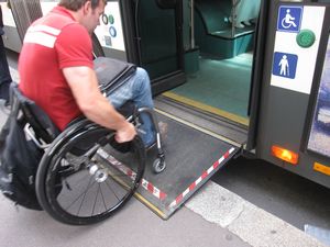
Buses are definitely the best option for accessible Paris public transportation. All of the bus lines that we used had wheelchair ramps making it easy to get on and off the busses.
To use the the busses, first buy a ticket or a “carnet” (pack of tickets) at a Tabac shop, a train station, or a subway station. Try to get the bus driver’s attention as he is pulling up. There are handicapped buttons on the side of the bus to get the driver’s attention, but we never had to press it. If the bus has a wheelchair ramp it will be at the middle door. The doors must be closed to extend the ramp, so don’t be alarmed if the bus driver lets the passengers off, closes the doors, and then extends the ramp for you.
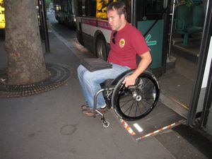
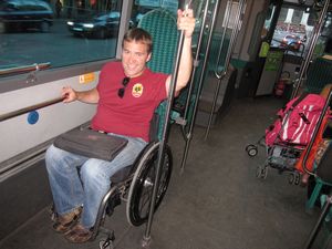
There are no tie-downs on the bus, but there is a spot for a wheelchair where you can sit backwards. Sometimes these areas are occupied by strollers. Most of the time we were there, parents would move their strollers out of the way so I could use the spot.
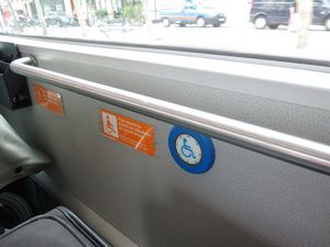
The wheelchair ramp on the busses is at the middle or rear door (depending on how long the bus is). Look for a blue wheelchair button on the side of the bus:
There is a spot on the buses for wheelchair users to sit backwards. Press the blue wheelchair button to alert the driver that you want to get off at the next stop:
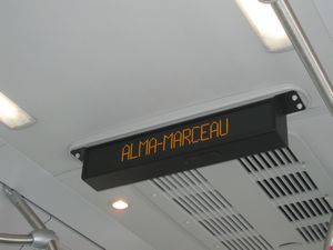
An electric sign on the ceiling will let you know what the next stop is (“Prochain arrêt”) as well as what the final stop is (“Vers”):
Accessible Bus Map
To figure out your way around town you will need to use a combination of bus maps. Start off by printing out these two maps. You may want to print them on multiple pages to make them larger:
1) Infomobi map of accessible public transportation
2) RATP map of all bus lines
The next step is to check this interactive map to find out exactly where the bus stops are located: www.ratp.info/orienter/cv/cartebus.php
Click on the UK flag in the upper left. Next click on the box labeled “Accessibility” on the right. The checkbox “Accessible Lines” will show lines that have buses with retractable ramps to board. The checkbox “Lowered floor bus lines” shows lines where the busses have low floors but are not wheelchair accessible. The zoom for the map is in the upper right.
For many neighborhoods you can view exactly where the bus stop is (there may be several bus stops for various bus lines within a couple of blocks of each other), follow these steps:
1) Select the “Accessible Line” box on the right
2) On the map, locate the little box next to the names of the bus stops and click on it
3) If you click on one of the bus lines, then the symbol with red lines and circles, you will open a diagrams showing the exact route of the bus line (shown in the picture on the left below)
4) Alternatively, you can locate the exact location of the bus stop. To do this, click on one of the squares where bus lines intersect, then the icon that looks like a map (blue square with the white lines)
5) When the map of the neighborhood comes up, click the plus sign in the upper right of the window (the website is not designed well…you may have to close some of your internet explorer toolbars to see the plus sign)
6) A window will open showing a map with the local streets and “bus” symbols showing you where the bus stops are (shown in the picture on the right below)
7) On this map you can find the location of the bus stop. Most bus lines will have 2 stops on opposite sides of the street depending on which direction it is going. (Busses in France drive on the right side of the street like in the US and unlike in the UK.) You can hover over the bus route names at the bottom of the page to show where they are.
If this process is exhausting, our accessible travel agents can do it for you!
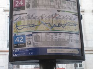
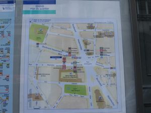
All the bus stops stops that we saw had a pole with a sign showing which bus lines stop there and how often. An example of these signs is shown in the picture on the left. The covered bus stops (which are not at every bus stop) had a map showing where the various bus lines stopped in the neighborhood (shown in the picture on the right):
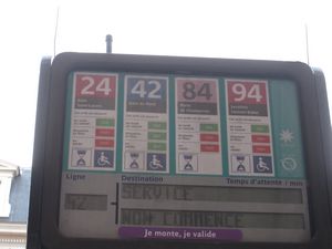
At some bus stops, the sign on the pole shows how many minutes until the bus arrives:
Other Bus Maps:
Map of accessible public transportation surrounding Paris
The night bus map (after 8:30 pm) including busses without ramps
The map of busses on Sundays and holidays (including busses without ramps)
Subway (a.k.a. Metro)
What is the difference between the Metro, the RER, and the SNCF? The Metro is the subway system inside the city. The RER is the train system to the suburbs. The SNCF is the train system across France.
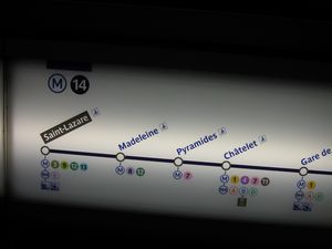
The only Metro line that has accessible stops and is useful for tourists is the M14 line. This line can get you between the Gare St. Lazare (where there are hotels and a train station to get to Versailles) and the stops near the Louvre and Notre Dame. The M14 also connects to Gare de Lyon which has trains to destinations in southeast France.
To get down to the train at an accessible station, you will typically have to take an elevator down to the ticketing level, then take a different elevator down to the train level. Sometimes different elevators will put you on different sides of the track. Signs by these elevators will tell you which direction the train is traveling by stating what the final stop is.
You can find an interactive map of trains and subways here:http://www.ratp.info/orienter/cv/carteparis.php
Here is a summary of the Metro lines:
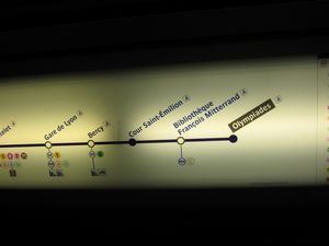
M14 metro – Accessible and possibly useful for tourists. Runs from Gare Saint-Lazare (train station to other parts of France) to the Pyramides station (one block from Musée du Louvre) to the Châtelet station (a couple of blocks from Saint-Chapelle and Notre Dame churches, also has transfer to RER “A” and “B”) to Gare de Lyon (train station to other parts of France) to Olympiades station in the southeast.
M13 metro – Accessible but not useful for tourists. Runs on the north side of town near Saint-Denis.
T2 – Accessible but not useful for tourists. Travels on the west side of the Peripherique (highway loop) from La Défense Grande Arche in the northwest to Issy Val de Seine in the southwest.
T3 – Accessible but not useful for tourists. Travels near the south side of the Peripherique from Pont du Garigliano in the southwest to Pte d’Ivry in the southeast.
RER train “A” – Accessible and useful for the La Defense business district to the west and Paris Disneyland to the east. Accessible station at Châtelet to transfer to RER train “B”.
RER train “B” – Accessible and useful to go from Charles de Gaulle airport in the north to Châtelet station near several accessible hotels in Paris)
RER train “C” – Accessible with assistance from an agent. Can be used to go to Versailles.
RER train “D” – Not useful for tourists
RER train “E” – Not useful for tourists
Signs inside the subway trains show that all the stops on the M14 line have elevators:
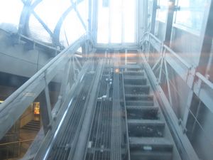
The Metro station at the Gare St. Lazare Metro station had a rather unique diagonal traveling elevator to exit.
Train Accessibility
The RER trains serve the Paris suburbs including Versailles, and the SNCF trains serve further destinations.
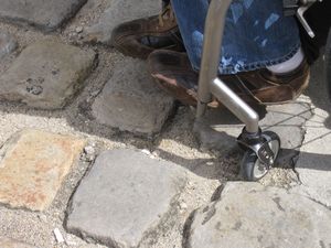
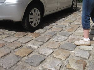
We found these 2 star smooth cobblestones in a courtyard of a building. These are very rare in Paris, and we did not see anything this rough on the sidewalks:
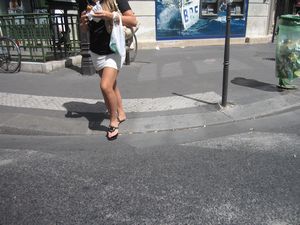
The vast majority of sidewalk curb cuts at intersections have gradual slopes like this one:
Read more:
Paris Accessible Travel – main page
Pros and Cons of Paris Disabled Access
13 Wheelchair Accessible Travel Tips for Paris France
11 Keys to Success for Paris Disabled Travel
Paris Accessible Travel Packages
Accessible Walking and Driving Tours in Paris
Accessible Paris Boat Tour on the Seine River
Highlights of Paris Accessible Driving Tour
Classic Paris Accessible Walking Tour
Wheelchair Accessible Tour of Paris Latin Quarter
Wheelchair Accessible Guided Tour of the Louvre Museum
Giverny & Versailles Wheelchair Accessible Tour
Accessible Hotels in Paris
Paris Accessibility Guide by John Sage
Paris Trip Planning by Sage Traveling – Travel with Ease!
Contact our Paris accessible travel consultants

"We could go on and on but this was the best trip that we could ask for. Our next trip will definitely be through you..."Read More...
"The Paris Accessibility Guide is the most valuable travel document I have ever encountered…"Read More...
"We had a splendid time in Europe, thanks to all your planning. We remarked again and again how difficult it would have been without your planning! Thanks again for the wonderful trip!"Read More...
"I wanted to let you and Mr. Sage know that we loved our accessible private tour of the Vatican…"Read More...
"Let me thank all you guys at Sage Traveling. I got my scooter in Berlin. It was a brand new Orion…"Read More...
"I am a wheelchair user and have just returned with my husband from a cruise which started in Istanbul and ended in Venice. The information you provided on both these cities was absolutely invaluable…"Read More...
"The hotel you recommended was very centrally located and within convenient walking distance to the Louvre and Notre Dame. We even walked to the Latin quarter and to the boat tour! Thank you again for making our trip a wonderful and manageable experience…"Read More...
"I just wanted to thank you for an excellent experience in Paris. The wheelchair was delivered exactly on time and we’ve been everywhere with it over the last two days…"Read More...
"We will certainly recommend your services to others and use you again in the future…"Read More...